Kathmandu
Sunday, July 12, 2026


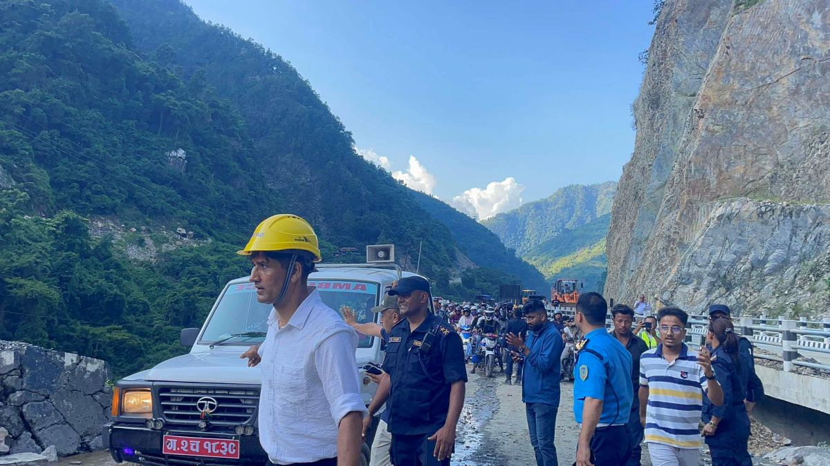
KATHMANDU: A massive landslide has once again blocked the Narayangadh–Muglin road for an indefinite period, stranding thousands of passengers during the Dashain vacations.
Authorities are urging travelers to use alternative routes while working to clear the debris, but the steep terrain and unstable slopes make restoration extremely difficult.
This 36-kilometer stretch is a crucial link in Nepal’s highway network, connecting Kathmandu to major border trade hubs that collectively handle around 90% of Nepal’s trade with India.
The road sees over 10,000 vehicles daily, including trucks carrying goods, essential supplies, and passengers.
Historically, it was narrow and wound through steep hills alongside the Trishuli River, making it highly vulnerable to landslides.
To address these risks, the road was upgraded, widening it to 9–11 meters and stabilizing over 100 slopes using a combination of engineering and bioengineering techniques.
This explainer answers key questions in a 12 question and answer format, covering topics such as accident history, economic costs, terrain and geology, weather hazards, delays in fund approval, coordination gaps, budget priorities, regulation of construction above the road, traffic management and enforcement, slope protection measures, broader safety concerns, and road design and construction standards.
Why is the Narayangadh–Muglin road strategically important?
Narayangadh-Muglin road is a key artery linking Kathmandu with southern trade hubs like Birgunj and Bhairahawa, which together handle 90% of Nepal’s cross-border trade.
Being part of the Asian Highway Network (AH 42), the corridor is critical for international commerce, tourism, and domestic connectivity.
Disruption of this section directly impacts the movement of goods, passengers, and essential supplies, causing economic losses and congestion. Trucks, buses, and private vehicles rely on this route, highlighting its importance for emergency response, public services, and regional development.
Recognizing its significance, the World Bank supported the Nepal-India Regional Trade and Transport Project (NIRTTP) in 2021 to upgrade this 40-year-old road to international standards.
The project focused not only on widening and paving but also on climate-resilient engineering, slope stabilization, and slope bioengineering using locally suited plant species.
This strategic intervention ensures safer, faster, and more reliable travel, improves trade competitiveness, and strengthens Nepal’s integration with regional transport networks, thereby supporting economic growth and reducing logistic bottlenecks.
How does geology affect road stability in this region?
The Narayangadh–Muglin road passes through steep hills and river valleys, with highly erodible soils and unstable rock formations. Monsoon rainfall saturates slopes, reducing soil cohesion and increasing the likelihood of landslides.
The Trishuli River erodes valley-side slopes, weakening foundations and threatening retaining structures. Historical cuttings and unregulated construction have further destabilized slopes.
Some slopes are steep, long, and highly active, causing frequent road closures and accidents. Complex geotechnical conditions required detailed drone mapping, soil testing, and geotechnical surveys under NIRTTP.
These assessments identified over 23 high-risk slopes needing advanced interventions such as pile-based retaining walls, anchored wire mesh, and reinforced earth structures.
Understanding the local geology was critical to designing slope stabilization solutions, selecting appropriate bioengineering plant species, and integrating drainage to prevent water accumulation.
The combination of site-specific engineering, nature-based solutions, and community engagement has significantly enhanced slope resilience, reduced landslide risks, and improved the reliability of this vital trade and transport corridor.
How does monsoon rainfall impact the road?
Monsoon rains saturate soil on steep slopes, increasing landslide risk even after slope stabilization. Excess water can accumulate in drainage systems or bypass bioengineered slopes, weakening soil cohesion.
The problem was addressed by integrating drainage channels, retaining walls, and vegetation cover to reduce water infiltration and erosion.
Continuous monitoring, early warning systems, and debris removal mechanisms are essential during heavy rainfall. Despite engineering interventions, intense rainfall events can temporarily block traffic, highlighting the importance of contingency planning and alternative routes.
Regular inspection and maintenance, particularly before and during the monsoon, ensure slope stability, protect travelers, and prevent economic disruption.
The project demonstrated that combining technical, ecological, and operational measures effectively mitigates monsoon impacts and enhances resilience.
What are the economic implications of road disruptions?
Landslides and road blockages directly affect Nepal’s economy. Trade shipments to border hubs like Birgunj are delayed, increasing operational costs and disrupting supply chains.
Tourism declines when passenger mobility is restricted, affecting hotels, transport services, and local businesses. Delays can cause spoilage of perishable goods and reduce overall competitiveness. The upgradation mitigated these risks by improving road reliability, shortening travel time, and enhancing safety.
However, overloading, lack of maintenance, and unregulated construction remain threats. Sustainable management, including traffic enforcement, slope monitoring, and community engagement, is critical to sustaining economic benefits.
Reliable road infrastructure not only reduces direct costs but also supports regional development, tourism growth, and disaster resilience, creating long-term value for the national economy.
How do alternative routes support travelers during landslides?
During major landslides such as the recent Tuin Khola blockage, authorities have been advising travelers to use alternative routes to keep trade and travel moving.
One detour runs through Dedhgaun via Khairenitar in Tanahun, part of a Gandaki Province “pride project” intended to link Mustang with the Tarai. This route, suitable mainly for small and light vehicles, follows the stretch Damauli–Khairenitar–Bhimad–Manpur–Dedhgaun–Bulingtar–Dhodeni–Gaindakot.
Distances along the way include 70 km from Muglin to Khairenitar, 7 km of blacktop from Khairenitar to Bhimad, 35 km of dirt road from Bhimad to Manpur, 40 km of blacktop from Manpur to Dedhgaun, and 70 km from Dedhgaun to Narayangadh.
Locals also note that motorcycles can reach the section by crossing a suspension bridge through Keshavtar, Sukhaura, Huslang, and Dharampani.
For vehicles heading toward Kathmandu, Kanti Lokpath remains a key option, while light vehicles under 10 tons are being redirected through corridors via Bardibas (Mahottari), Hetauda (Makwanpur), Butwal (Rupandehi), Kawasoti and Gaindakot (Nawalparasi Bardghat Susta East).
Smaller vehicles bound for Pokhara often rely on the Butwal–Palpa route. These alternatives help ensure the steady movement of goods, passengers, and emergency services, thereby reducing economic and social disruption during road closures.
Local authorities have reinforced the use of road signage, public advisories, and coordination measures to guide motorists safely.
What challenges did the pre-upgraded road face?
Before 2021, the Narayangadh–Muglin road was only 5–5.5 meters wide, dangerously narrow for the growing volume of vehicles.
Its alignment along steep hills and the Trishuli River made it highly prone to landslides, particularly during monsoon rains, which frequently triggered slope failures and blocked traffic for hours. Pavement deterioration was accelerated by overloaded trucks, leading to potholes, uneven surfaces, and safety hazards.
The 2015 earthquake further destabilized slopes, increasing vulnerability to erosion and collapse. Riverbank erosion on the valley side compounded risks, while local cuttings and construction disturbed slope integrity.
Travel on this road was time-consuming, with frequent congestion and delays, negatively affecting trade, tourism, and passenger safety. Drivers reported fear and unpredictability during monsoons, highlighting the urgent need for comprehensive slope stabilization, proper drainage, and wider carriageways.
These challenges prompted the World Bank-supported NIRTTP to focus on resilient construction and bioengineering solutions that could withstand climate-induced hazards and seismic risks.
How did the World Bank-supported NIRTTP upgrade the road?
The NIRTTP implemented a comprehensive upgradation of the Narayangadh–Muglin road, widening it to 9–11 meters and upgrading it to Asian Highway Network standards.
The project combined conventional engineering with innovative, nature-based solutions to address landslide risks. Both sides of the road were widened where feasible, with mountain-side excavation and valley-side retaining walls.
Over 100 slopes were treated using bioengineering techniques, integrating local grasses, shrubs, and plants with proper drainage and retaining structures.
Complex slopes received advanced interventions, including wire mesh netting, anchors, rock bolts, pile-based retaining walls, geo-reinforced earth walls, and micro piles.
Drone mapping, geological surveys, and bathymetric studies guided the site-specific designs. Immediately after slope cuts, the World Bank assisted in implementing vegetation and stabilization measures, ensuring timely and effective slope protection.
These measures reduced monsoon-related road closures, improved safety, and strengthened the road’s resilience against future climate-induced hazards.
By combining structural engineering with ecological solutions, the project demonstrated how infrastructure can be both safe and environmentally sustainable, providing a model for future highway projects in Nepal and the region.
What bioengineering solutions were implemented?
Bioengineering techniques were central to the NIRTTP’s slope stabilization strategy. More than 100 slopes received treatment using locally adapted grasses, shrubs, and plants combined with structural measures like retaining walls, geogrids, and drainage systems. Immediately after slope excavation, workers implemented vegetation planting, soil binding, and surface protection measures.
Local communities were employed, leveraging their knowledge of terrain and climate conditions, ensuring proper establishment and maintenance of plant species.
Bioengineering enhanced soil cohesion, minimized surface erosion, and provided a sustainable, low-maintenance slope protection system. For complex slopes, bioengineering was integrated with advanced engineering solutions such as wire mesh, anchors, and micro piles.
The World Bank provided technical guidance to ensure these nature-based solutions were applied according to international standards, following the Department of Roads’ reference manuals.
Timely intervention, coupled with ongoing maintenance, ensured slopes could withstand monsoon rains, reduce closures and improve road safety.
This integrated approach demonstrated the effectiveness of combining structural engineering with ecological methods for sustainable infrastructure development in mountainous regions.
How were complex slopes treated?
Steep, long, and highly active slopes along the Narayangadh–Muglin road required advanced engineering solutions.
The project conducted detailed drone mapping, geological surveys, and geotechnical assessments to design site-specific interventions.
For 23 high-risk slopes, wire mesh netting with anchors and rock bolts was installed alongside retaining walls, drainage channels, and bioengineering techniques.
Slopes facing river erosion were further reinforced with pile-based retaining structures, anchored walls, geo-reinforced earth walls, and micro piles.
Bathymetric surveys guided riverbank stabilization, ensuring proper design under variable hydrological conditions. These complex slope interventions significantly reduced monsoon-related road closures, improved traffic safety, and enhanced resilience to future disasters.
The project demonstrated that effective management of high-risk slopes requires a combination of structural engineering, ecological stabilization, continuous monitoring, and community engagement.
Lessons learned from these interventions have been compiled into supplementary guides for future road construction projects in Nepal, providing engineers with practical frameworks for resilient infrastructure development.
How does overloading affect pavement and slope stability?
High traffic volumes, particularly overloaded trucks, exacerbate road and slope deterioration. Trucks transporting goods, sometimes beyond legal limits, exert excessive stress on pavement and retaining structures, accelerating wear and causing potholes, surface cracking, and uneven road conditions.
Overloaded vehicles also contribute to slope instability by increasing vibrations, soil compaction, and structural strain on retaining walls. According to NIRTTP assessments, pavement service life could be reduced by up to 60% under extreme overloading.
Enforcement of weight limits, traffic monitoring, and public awareness campaigns are essential to protect infrastructure investment.
Technical guidance was ensured to incorporate structural reinforcements that could withstand typical traffic loads, while slope stabilization measures were designed to resist additional stress from overloaded vehicles.
Combining proper traffic management, structural engineering, and bioengineering solutions ensures the long-term durability of the road, minimizing disruptions and economic losses due to closures or repairs.
What lessons were learned from slope stabilization?
The NIRTTP highlighted that integrated approaches—engineering measures, drainage, and bioengineering—are essential for slope resilience.
Timely intervention after excavation, selection of local plant species, and community engagement in slope maintenance were critical success factors.
Detailed investigation is mandatory for complex slope failures, combining drone mapping, geotechnical studies, and hydrological assessments. Construction upstream or downstream must be carefully regulated to prevent destabilization. Early warning and traffic management systems reduce risk to life and property during extreme events.
Lessons from over 100 treated slopes have been compiled into supplementary guides for engineers, providing a reference for resilient road construction in Nepal.
The World Bank emphasized the importance of combining structural reinforcement with ecological solutions to enhance long-term sustainability, reduce maintenance costs, and mitigate climate-related disaster risks.
These lessons are applicable to other mountainous regions with similar geotechnical challenges, offering a replicable model for climate-smart infrastructure development.
How has the upgrade improved travel and trade?
The Narayangadh–Muglin road upgrade has reduced travel time from two hours to roughly 50 minutes. Widening, slope stabilization, drainage improvement, and resilient pavement have made journeys safer and more reliable.
Drivers report reduced anxiety and delays, particularly during monsoons. The road’s improved capacity and stability directly benefit trade by ensuring uninterrupted movement of goods to border hubs like Birgunj and Bhairahawa.
Fuel consumption and vehicle wear have decreased, enhancing cost efficiency for operators. Passenger transport is safer, encouraging tourism along the corridor.