Kathmandu
Sunday, July 12, 2026


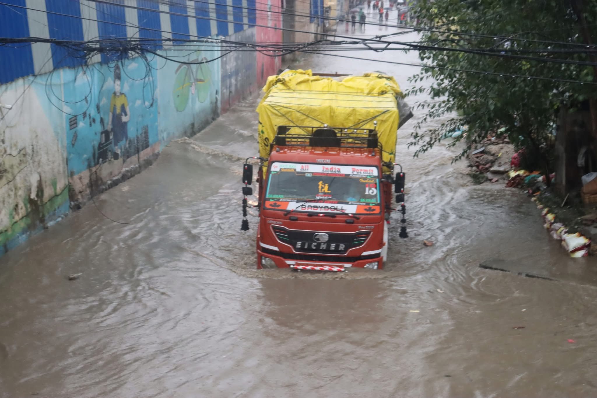
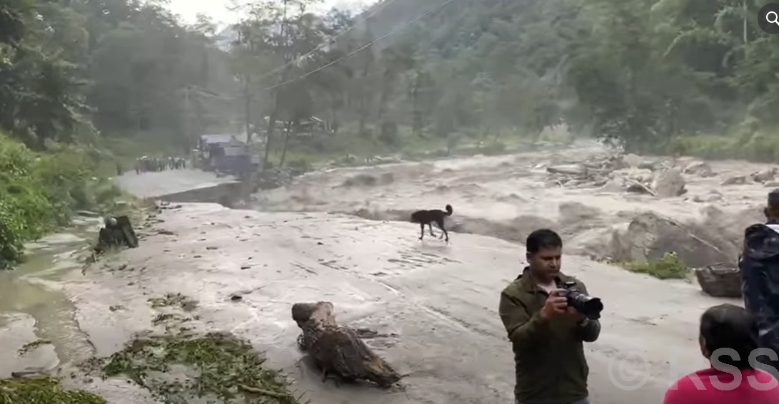
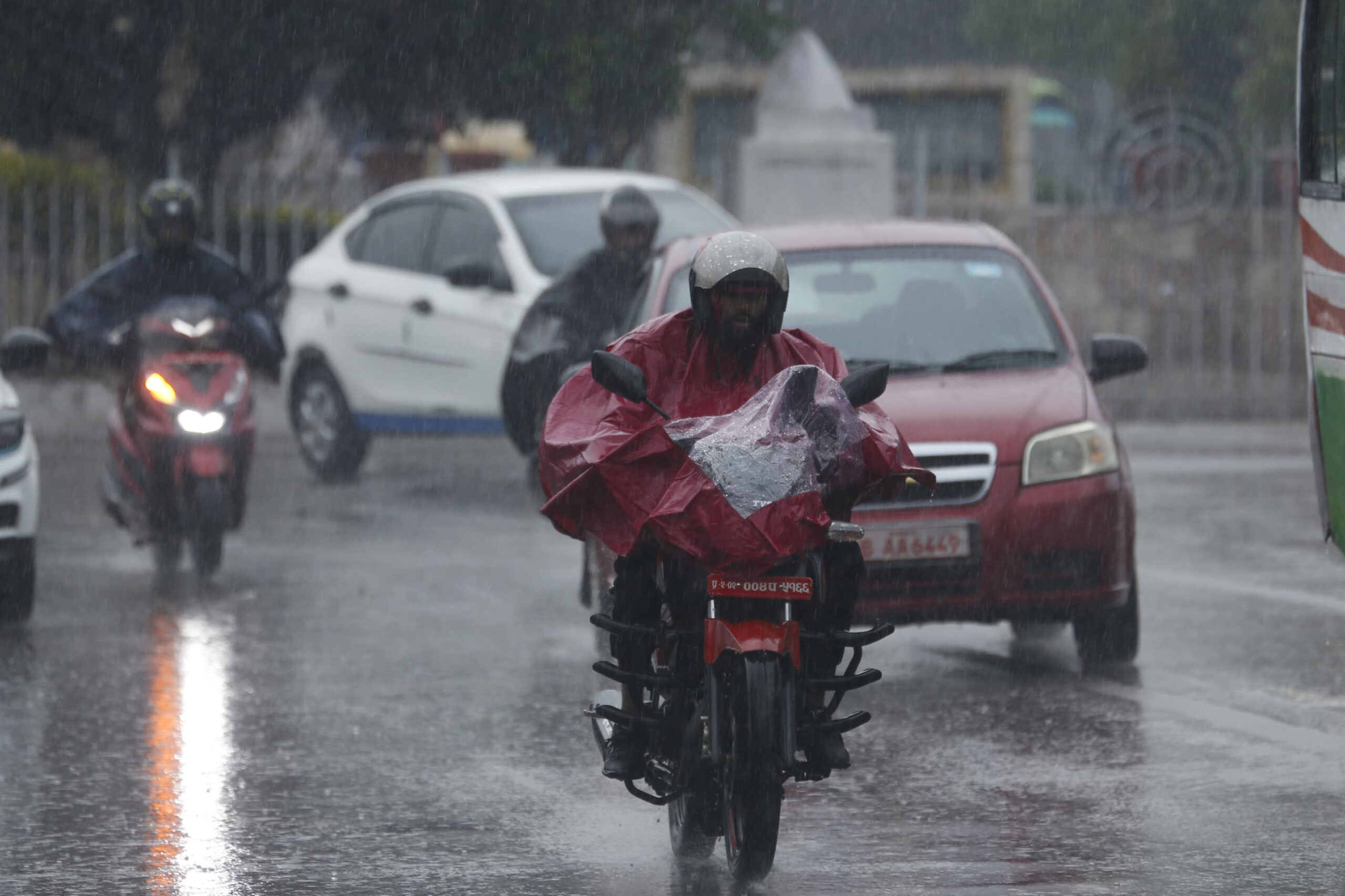
KATHMANDU: Nepal is facing severe floods and landslides following days of heavy monsoon rainfall. As of 3 PM on October 5, official reports indicate 49 deaths, 11 missing, and 17 injured, though authorities warn that the toll is expected to rise as rescue operations continue and information from remote areas is collected.
Rivers such as Koshi, Mechi, Narayani, and Bagmati have exceeded danger levels, flooding low-lying settlements and breaching embankments.
Mountainous terrain, deforestation, and unprotected slopes exacerbate hazards, while highways and bridges remain blocked in several districts.
This year, the government’s proactive response, improved disaster information systems, and early warnings have minimized casualties compared to last year when leadership dismissed disaster losses. Rescue operations continue across affected areas.
How many people have been affected so far?
As of 3 PM on October 5, authorities report 49 fatalities, 11 missing, and 17 injured across multiple districts.
Ilam district alone accounts for 37 deaths and five missing persons, mostly in Manebhanjyang, Deumai, and Sandakpur.
Koshi Province reports 46 deaths, while three occurred in Madhesh Province. Over 500 households in Jhapa, 70 in Kavre, and numerous others have been displaced.
The government emphasizes that these figures are preliminary, as heavy rainfall and landslides restrict access to remote villages. Relief teams continue to reach stranded communities, and the final toll is expected to rise.
Why do highways frequently get blocked during monsoon rains?
Nepal’s highways are highly susceptible to blockages during heavy rainfall because of its steep, mountainous terrain. Saturated slopes often trigger landslides, sending mud, rocks, and debris onto roadways.
Riverbank erosion and flash floods can wash away bridges or weaken embankments, particularly on highways such as Prithvi, BP, Araniko, and Narayangadh-Muglin.
Narrow passes, insufficient retaining walls, and deforestation exacerbate vulnerability. During the current monsoon, multiple points on major highways were blocked, delaying emergency transport and rescue operations.
These blockages highlight the need for slope stabilization, embankment protection, and continuous monitoring to reduce disruptions and improve public safety.
How has the government’s response improved compared to last year?
Last year, under then-Prime Minister KP Oli, the government publicly downplayed disaster losses, creating confusion and delaying relief efforts.
It faced severe criticism for failing to deploy helicopters to rescue people stranded on the rooftops of their homes in Kathmandu, the nation’s capital.
In contrast, this year’s government has acted proactively, coordinating timely rescue operations and using better information systems to reach affected areas more efficiently, which has helped reduce casualties despite heavy rainfall and widespread landslides.
But, this year, early warnings were issued, embankments reinforced, and emergency shelters prepared in flood- and landslide-prone districts. Coordination between the Nepal Army, Nepal Police, Armed Police Force and local administration ensured timely evacuation.
Real-time monitoring of river levels, rainfall, and road conditions enabled rapid response. As a result, despite heavy rainfall, casualties were lower than expected.
Improved disaster management, combined with community cooperation, demonstrates the importance of preparedness, early warnings, and transparent reporting for minimizing human and economic losses during monsoons.
Which rivers have caused the most damage?
The Saptakoshi river was the most destructive. It reached a peak flow of 431,000 cusecs, exceeding danger levels and prompting the opening of all 56 barrage gates.
Saptakoshi breached embankments in Sunsari, Morang, and Udayapur, inundating villages and farmland. Bagmati, Sunkoshi, Dudhkoshi, Bhotekoshi and Mechi rivers also overflowed, affecting settlements in Kathmandu, Lalitpur, Sindhupalchok, Makwanpur, Rautahat, Ramechhap, Kavre, and Jhapa.
Controlled water releases prevented catastrophic downstream flooding, but many communities faced evacuation and property damage.
Early warnings enabled residents to relocate safely, mitigating casualties. Continuous monitoring remains critical as rainfall persists, potentially raising river levels further.
Which districts were most affected by landslides?
Ilam, Rasuwa, Dhading, Kavre, Makwanpur, Tanahun and Bhaktapur experienced the most severe landslides. Ilam reported 37 deaths, mostly in Manebhanjyang and Deumai. Dhading’s Jyamire Ghat and Tanahun saw multiple slope failures along Prithvi Highway.
Kavre-Bhaktapur’s Sanga area experienced debris flow disrupting the Araniko Highway. Steep hillsides, loose soil, and deforestation contributed to slope instability.
Landslides buried homes, farmland, and local roads, complicating rescue efforts.
Authorities continue debris removal and slope stabilization work, but ongoing rainfall means additional landslides remain a serious risk.
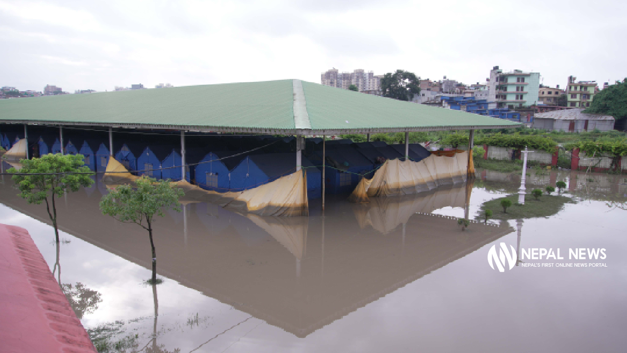
How many households have been displaced?
Preliminary assessments indicate over 500 households in Jhapa, 70 in Kavre, and numerous others in Ilam, Dhading, and Makwanpur districts were displaced.
Most evacuees lived near rivers, floodplains, or unstable hillsides. Emergency shelters in schools, community centers, and local buildings provided temporary accommodation, food, and medical aid.
Early warnings helped evacuate residents before peak flooding, reducing casualties. Authorities continue to monitor vulnerable areas and provide support for displaced families.
Residents are advised to stay alert to river levels and rainfall updates, as secondary floods and landslides remain possible in affected districts.
How have highways and bridges been affected?
Major highways, including Prithvi, BP, Araniko, and Narayangadh-Muglin, faced partial or complete closure due to landslides and washed-out roads.
Mechi Highway lost multiple bridges, including the Biring Bridge in Jhapa. Temporary diversions and road-clearing operations by JCBs and local authorities have partially restored access, prioritizing emergency vehicles.
Suspension bridges and pedestrian crossings in Ilam, Kavre, and Jhapa suffered damage, leaving some villages isolated.
Mountainous terrain combined with heavy rainfall increases sudden road and bridge failures, highlighting the importance of preventive maintenance, slope stabilization, and bridge reinforcement to ensure safety and mobility during monsoons.
How were flight operations impacted?
Tribhuvan International Airport temporarily suspended flights during heavy rainfall and low visibility. Domestic flights resumed Sunday morning with 140 flights scheduled, while some international flights were diverted temporarily to India or Bangladesh.
Improved weather monitoring and runway clearance allowed the airport to reopen safely. Delayed flights were rescheduled with extended operational hours. Coordination between the airport authority and meteorological departments ensured passenger safety.
Travelers are advised to confirm flight schedules, as sudden weather deterioration can cause further delays. Effective planning and monitoring minimized disruptions compared to past monsoon seasons.
How has the information system helped this time?
Improved disaster information systems enabled real-time monitoring of rainfall, river levels, and landslide-prone areas. Satellite imagery and early-warning alerts were disseminated via SMS, radio, and local administration channels.
Road blockages and river overflows were reported immediately, allowing authorities to deploy rescue teams and pre-position emergency shelters.
Unlike last year’s delayed reporting and misinformation, these systems ensured timely evacuation, rapid response, and efficient resource allocation.
Officials credit the digital monitoring infrastructure for saving lives and improving coordination among agencies and communities, demonstrating the critical role of technology in disaster management.
What precautions should residents take?
Residents in flood- and landslide-prone areas should evacuate to safe shelters, avoid riverbanks, floodplains, and steep slopes, and follow local administration instructions.
Travelers should avoid blocked highways and risky routes like Prithvi, BP, Araniko, and Narayangadh-Muglin. People should carry emergency supplies, remain alert for updates, and report missing persons immediately.
Authorities emphasize caution even after rainfall subsides, as landslides and secondary floods can occur unexpectedly. Early evacuation and adherence to official guidance are critical to reducing casualties and property loss during ongoing monsoon hazards.
How are rescue and relief operations being coordinated?
The Home Ministry, Nepal Army, Nepal Police, Armed Police Force and local disaster management committees coordinate evacuation, relief, and emergency medical aid.
Temporary shelters have been established in schools, community centers, and emergency holding areas. Teams clear blocked roads, assess structural damage, and transport stranded residents to safety.
Volunteers assist with food distribution and medical care. Real-time monitoring of river flows and rainfall guides deployment of resources. The proactive response, improved coordination, and early warning systems minimized human losses compared to past monsoons and enabled more efficient rescue operations.
How are schools and education affected?
Schools in high-risk districts were closed preemptively due to heavy rainfall, landslides, and flooding. Students in Ilam, Dhading, Kavre, and Sunsari remained home or were relocated to safe shelters.
Educational materials and online resources were provided to continue learning where feasible. Authorities prioritize student safety, ensuring that schools are inspected before reopening.
Community centers and emergency shelters for displaced households often serve as temporary classrooms. Proactive planning minimized risk to students and staff, highlighting the importance of integrating disaster preparedness into school safety protocols.
How does Nepal’s geography worsen the impact of monsoon rains?
Nepal’s geography, dominated by the Himalayas, mid-hills, and river valleys, makes it highly vulnerable to heavy rainfall. Steep slopes, narrow valleys, and unstable soil increase landslide and flash flood risks.
Rivers originating in high mountains descend rapidly, carrying sediment and debris into settlements. Deforestation and unplanned construction further destabilize slopes.
Narrow passes along highways become blocked by debris, while riverbanks erode easily. Flood-prone plains in Madhesh face inundation from swollen rivers.
Geography combined with heavy monsoon rains requires continuous monitoring, slope protection, embankment reinforcement, and early-warning dissemination to reduce human and economic losses.
How does climate change influence Nepal’s monsoon patterns?
Climate change is increasing the intensity and unpredictability of monsoon rainfall in Nepal. Warmer temperatures enhance atmospheric moisture, leading to heavier precipitation in shorter periods.
Glacial melt contributes to higher river flows, while deforestation and soil degradation worsen flood and landslide risks. Sudden cloudbursts and erratic rainfall patterns create localized disasters, overwhelming drainage systems and embankments.
Experts warn that climate-adaptive infrastructure, reforestation, and community awareness are essential to cope with increasingly severe monsoons.
Early warning systems and disaster preparedness plans must adapt to this changing climate to prevent higher casualties and damage.
What lessons are drawn from last year’s response?
Last year, when then-PM Oli dismissed the severity of disasters, losses were underestimated, and emergency response was delayed.
Communities suffered preventable casualties and property damage. This year, proactive government planning, early warning dissemination, and coordinated rescue efforts demonstrate that transparent communication and preparation are critical.
Investments in information systems, monitoring, and infrastructure have improved response times. Public trust and cooperation also increased evacuation efficiency.
The contrast underscores the importance of leadership that recognizes disaster risks and mobilizes resources promptly, ensuring safety and resilience during Nepal’s annual monsoon.
What economic impact is expected?
Monsoon floods and landslides disrupt agriculture, transportation, and local commerce. Crops in floodplains, especially in Sunsari, Morang, and Jhapa, are inundated, causing immediate losses to farmers.
Blocked highways delay goods, affecting trade and market supply chains. Infrastructure damage, including bridges and roads, will require extensive repair costs.
Hydropower and tourism sectors also face temporary disruptions. While precise economic losses are being assessed, preliminary reports indicate hundreds of billions of rupees in damage.
Rapid response, reconstruction, and disaster insurance mechanisms are critical to mitigating long-term economic impact.
How are citizens and local communities assisting?
Local communities play a vital role in disaster response. Volunteers help evacuate families, distribute food and medicine, and clear roads and debris.
Community-based early-warning systems inform residents of river overflow and landslide risks. Religious organizations, youth groups, and NGOs contribute manpower, shelters, and logistical support.
Citizens also share information through social media and radio, aiding authorities in locating stranded individuals. Public participation enhances official response, reduces casualties, and fosters resilience in disaster-prone regions.
Are hospitals and medical facilities prepared?
Hospitals in affected districts, including Ilam, Dhading, Kavre, and Sunsari, activated emergency protocols, ensured staff availability, and stocked essential medicines.
Temporary medical camps were established near shelters for displaced households. Health teams focus on trauma care, flood-related infections, and sanitation management.
Ambulances and mobile medical units are deployed to remote villages. Authorities coordinated with the Ministry of Health to prioritize districts with highest casualties. Preparedness measures have reduced mortality and provided timely care to affected populations.
What is the government doing to prevent future disasters?
The government is investing in slope stabilization, embankment reinforcement, reforestation, and hazard mapping. Early-warning systems, real-time monitoring of rivers, rainfall prediction models, and community awareness campaigns are strengthened.
Policy focus includes sustainable urban planning, regulating construction in vulnerable areas, and establishing rapid-response task forces. Lessons from past monsoons are integrated into disaster management plans. These measures aim to reduce human, economic, and infrastructure losses during future monsoon events.
What is the public advised for the coming days?
Residents are advised to remain vigilant, monitor river levels, avoid risky roads, and follow local administration instructions. Travelers should postpone non-essential trips along highways prone to landslides or flooding.
Evacuations in high-risk zones should continue as needed, and citizens should maintain emergency supplies. Even after rainfall subsides, landslides and river overflow can occur.
Authorities urge cooperation with rescue operations and reporting of hazards to prevent additional casualties. Public alertness and adherence to warnings remain key in navigating the ongoing monsoon crisis.