Kathmandu
Tuesday, February 10, 2026


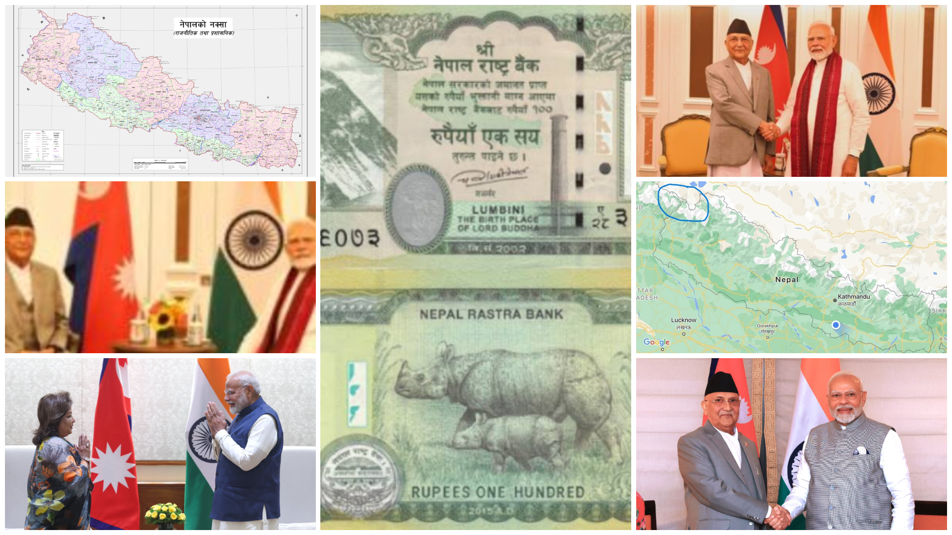
KATHMANDU: The Nepal-India border dispute involving the territories of Kalapani, Lipulekh, and Limpiyadhura is not a new one. The dispute, usually dormant, keeps hitting the headlines periodically. Most recently, the issue was under the spotlight towards the end of November when Nepal issued banknotes of the Rs 100 denomination, bearing the image of Nepal’s updated political map, which incorporates the disputed territories. The Indian media and academia started “crying foul.” Once again, news reports and articles appeared in both countries with their own sets of claims and counterclaims.
Before that, the border dispute was highlighted during former Prime Minister KP Sharma Oli’s China visit a few days before the Gen Z revolt. It was reported that during the 2025 Shanghai Cooperation Organization Summit, Oli had reminded Chinese President Xi Jinping that Lipulekh, Kalapani, and Limpiyadhura are sovereign Nepali territories as per the Treaty of Sugauli reached between British India and Nepal. Oli also protested against the India-China agreement to conduct bilateral trade via Lipulekh without so much as consulting Nepal.
China’s response was restrained. Reportedly, the Chinese president did not reject Nepal’s claim, but he also did not endorse it. Instead, he reiterated China’s standard line: “This is between Nepal and India and must be sorted out amicably through mutual understanding on both sides.”
It was a polite but clear message. Beijing would not meddle in the Nepal–India border dispute, and it would not relent on its 2015 pledge to India regarding the use of Lipulekh for bilateral trade.
While all this makes it clear that it is Nepal and India that will have to find an amicable solution to their most contentious border dispute through diplomacy, let’s dig a bit deeper into the dispute and try to explore the possibilities and impossibilities associated with it.
A dispute rooted in history
The story of Kalapani, Lipulekh, and Limpiyadhura stretches back more than two centuries.
The Anglo-Nepalese War ended in 1816 with the Sugauli Treaty. The treaty defined Nepal’s western boundary along the Kali River. The treaty, however, did not explicitly identify the location where the river was born.
Nepal asserts that the river originates from Limpiyadhura, the most western origin, and this would place the Kalapani-Lipulekh area of Nepal within it. India points to a much smaller stream and asserts that the river originates much to the east, from Lipulekh, adjusting the border and taking over the claimed 372 square kilometers into India.
This ambiguity had been dormant for decades. But in the 1950s, following the demise of the Rana rule and the opening of Nepal to the external world, India stationed a small army unit in the area. Matrika Prasad Koirala was then the prime minister of Nepal.
Then came the short, sharp war between India and China in 1962. After the war, India strengthened its military hold in Kalapani, reportedly with Nepal’s temporary consent at the time. However, those “temporary” deployments later became permanent outposts, and roads, barracks, and supply lines followed later, slowly cementing India’s hold.
In the late 1960s and early 1970s, during King Mahendra’s rule, 17 Indian Army posts, established during Prime Minister Matrika Prasad Koirala’s tenure, were removed from Nepal’s northern frontiers. “But India dillydallied and later refused to vacate Kalapani. Then Nepal did not follow up, and the entire area was comfortably controlled by India,” says senior political analyst Bharat Dahal in a video interview.
Flashpoints of the 21st Century
The Lipulekh border dispute was a long-simmering problem until it broke out in public consciousness in May 2020. India’s Defence Minister Rajnath Singh inaugurated a new road to Kailash Mansarovar, Tibet’s pilgrimage site, through Lipulekh. Nepal was shocked. For Nepalis in general, the news was a rude awakening: it was a road going across territory that belonged to Nepal.
The Nepal government responded immediately. Nepal released a new map of its territory that incorporated Kalapani, Lipulekh, and Limpiyadhura. A unanimous vote in parliament ratified the map, and a new amendment was made to the constitution entrenching the map. It was greeted back home as an act of bold sovereignty, but India was enraged and attacked Nepal’s map, calling it an “artificial claim.”
There was some unwinding of tensions in subsequent years but no resolution of the issue. Then Beijing added fuel to troubled waters in 2023 by issuing a new map placing Lipulekh in India. Nepal objected vehemently, but China did not alter its map.
And now in 2025, India and China have again agreed to the expansion of trade via Lipulekh, while Nepal sits alone—watching two giant neighbors strike deals across territory it claims to be its own.
Why Kalapani matters
It could seem to others a far-off feud regarding dry highlands. But Kalapani-Lipulekh-Limpiyadhura was a matter of ultimate geostrategic and symbolic significance to Nepal.
It’s history first. Nepal argues that records dating back to even the mid-19th century—records of taxes paid, maps drawn up by British surveyors, and hydro studies—all testify that the Kali River has its origin at Limpiyadhura and not at Lipulekh. By that same reasoning, that’s part of Nepal’s territory.
Second, it is a matter of dignity. For a small state sandwiched between two giants, the perception of sovereignty is a valuable thing. Yielding ground even on a symbolic level would be regarded as a national embarrassment.
Third, this concerns geopolitics. Lipulekh is a geopolitical trijunction between India, Nepal, and China. Control of the pass has both symbolic and security implications. For India, a road connection to Mansarovar via Lipulekh is a vital link to Tibet. For China, coordination at Lipulekh falls within its overall trade and border policy. For Nepal, exclusion is an insult and a danger.
In Nepal, the conflict has become intimately entangled in internal politics. Politicians across the spectrum cite Kalapani, Lipulekh, and Limpiyadhura to polish their own credentials as staunch nationalists.
In 2020, Oli’s government was swept up in a tide of nationalist opinion after releasing the new map. He was phenomenally popular, at least until then. Five years later, in 2025, Oli made news again—this time because he took up the matter personally with Xi Jinping.
Critics say such gestures only yield rhetoric rather than results. “Oli spoke bravely, yes,” a commentator stated, “but what did he achieve? China repeated its old line. India almost ignored him. Mere nationalist poses at home do not alter facts on the ground.”
Unanswered diplomatic notes
Since 2015, Kathmandu has dispatched note after note, couched in diplomatic language but ceaselessly conveying the same iron message: Lipulekh, Kalapani, and Limpiyadhura are part of Nepal.
The first formal protest came in May 2015, when India and China announced they would use Lipulekh as a trade route. Caught off guard was Nepal, which reminded both neighbors a part of the pass was within its border. An answer was not returned.
Years later, upon New Delhi’s publication of its updated political map in November 2019, Kathmandu once again forwarded its protest, claiming that these disputed places belonged to Nepal. New Delhi was unperturbed in response, and Kathmandu then subsequently in the same month raised another note wherein historical records and treaties were attached to establish that Limpiyadhura was actually the origin point of the Kali River and hence formed the west flank of Nepal.
It was a cycle of disregard that persisted. Nepal protested in May 2020 when India constructed and opened a road to Kailash Mansarovar via Lipulekh. Kathmandu even reminded Delhi officially in December the same year that it had revised its map—the legendary “chuche naksa”—to include Limpiyadhura. Yet again, silence.
By August 2021, the protests had turned deeply human. When Indian security personnel allegedly cut the rope of a tuin (improvised cable crossing) across the Mahakali, a 33-year-old Nepali, Jay Singh Dhami, was swept away and never found. Nepal’s note expressed grief and outrage, also objecting to Indian helicopters flying into its airspace. Later, in December 2022, yet another note protested road expansion on the Mahakali riverbank.
And this cycle did not cease in India. Nepal confronted Beijing as well. Its first note, submitted to Beijing in 2015, objected to China’s pact with India to make Lipulekh a trade corridor. Kathmandu reminded Beijing in May 2020 that this new road to Kailash Mansarovar that was recently opened went across Nepali territory.
Most recently, on 21 August 2025, the Nepal government officially complained that China made another pact with India to trade via Lipulekh without even seeking Kathmandu’s opinion.
But across all these years and all these notes, the answers never came—or when they did, they were evasive. The silence from both Delhi and Beijing has been deafening, leaving Nepal’s protests hanging in the air like unanswered letters. To Nepalis, the ignored notes are more than paperwork; they are reminders of a small nation’s voice echoing between two giants, struggling not to be erased from its own map!
An Unfinished Tale
Even after over two hundred years of signing the Sugauli Treaty, the dispute about where exactly the Kali River begins continues to define the politics of the Himalayan nation of Nepal. Maps have been crafted and re-crafted. Roads have gone up. Complaints have been filed. But still the debate continues, a testament to how borders sketched out in ink can take centuries to fix on the ground.
For the time being, Kalapani, Lipulekh, and Limpiyadhura remain symbols — of history, of pride, of sovereignty — and of Nepal’s perpetual problem of finding a comfortable middle ground between two big powers.
Today, Nepal is left with a grim reality: that it often has to play defense in the big chessboard of Asian geopolitics. But as Kalapani’s tale demonstrates, a small state can keep hopes alive against history’s forgetfulness.
The road ahead
As things stand, India continues to control Kalapani and is in a comfortable position to use Lipulekh for trade with China. China, while professing respect for Nepal’s sovereignty, remains committed to its agreement with India. Nepal continues to assert its claim but lacks the leverage to enforce it.
Diplomats say the only path forward is quiet negotiation between Kathmandu and New Delhi. Kathmandu has already taken initiatives for that several times. India’s long silence or outright rebuttal of Nepal’s claims and use of the same as a tactic to avoid negotiations with Nepal would mean that India lacks proof that Kalapani, Lipulekh, and Limpiyadhura are Indian territories.
Therefore, talks between the two very close neighbors to sort out the border disputes are a must. But such talks are fraught with difficulty. For India, ceding territory — however small — would set a precedent it wishes to avoid. For Nepal, accepting the status quo would be politically suffocating.
However, ironically, when Nepal and India meet at the highest level, during meetings between the prime ministers of the two countries, it is said no Nepali PM ever raises the matter. The dispute is not discussed at all, not even mentioned. But the same politicians deliver blood-boiling speeches in Nepal. This political double-standard must change if a solution to the most contentious border dispute between Nepal and India is to be found ever.