Kathmandu
Monday, July 27, 2026


While standard concrete markers line the Nepal-India border, a unique iron pillar standing at the Matihani-Madhwapur crossing puzzles locals, border experts, and state authorities alike.
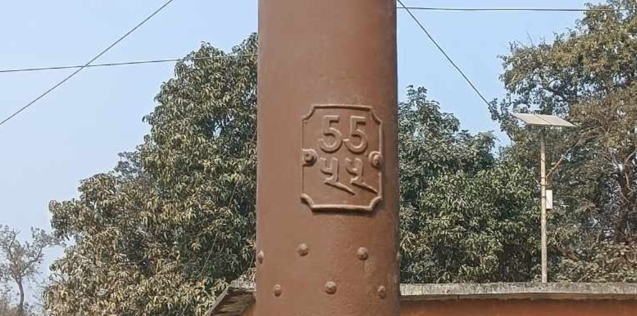
MAHOTTARI: At the borderline between Matihani Municipality-8 in the Mahottari district of Madhesh Province, Nepal, and Madhwapur Bazar in the Madhubani district of Bihar State, India, stands a unique iron pillar. This structure is entirely different from the other standard concrete markers located along the Nepal-India border. It stands out significantly because state authorities lack clear answers regarding its history, objective, and official records.
The pillar is located southwest of the concrete bridge built over the Bighi River, which separates the borders of Mahottari and Dhanusha. The number “55” can be seen written on it in both English and Devanagari. However, no official details regarding its length, thickness, or period of construction are available.
In terms of shape, it resembles an iron utility pole used for stringing electric wires. Generally, rust degrades iron materials over time, but no such deterioration is visible on this pillar. For its protection, cement concrete molding has been poured at its base, and Nepali security personnel maintain a presence nearby for security.
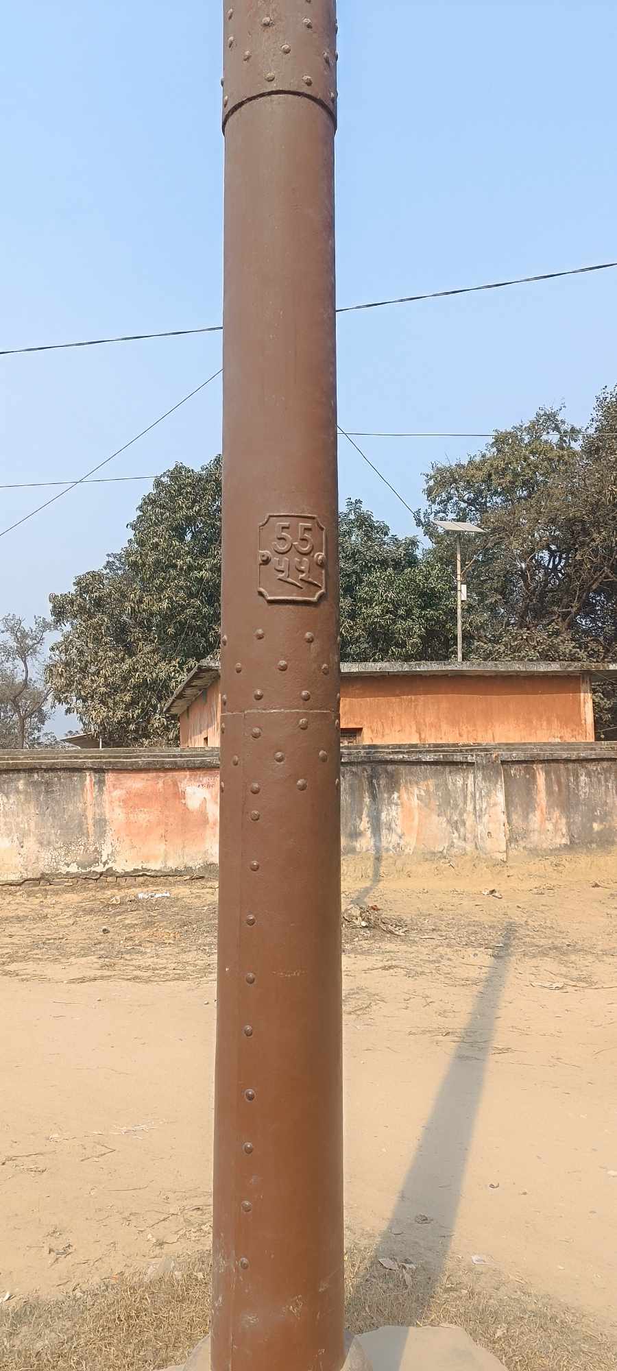
Iron pillar in Matihani. Photo: Rakesh Chaudhary
Matihani Municipality itself does not possess adequate information about it. When the author filed a Right to Information (RTI) application at the Department of Survey to gather details, the department indicated that the Armed Police Force (APF) or the Ministry of Foreign Affairs might hold information about it. Upon contacting the Armed Police Force, Nepal No. 9 Battalion Headquarters in Mahottari, the response received was that although they had heard about the existence of the iron border pillar, detailed information was unavailable.
Experts themselves unaware
Border experts have written extensively about the Nepal-India border and its markers. According to a working paper by border expert Buddhi Narayan Shrestha, the survey and demarcation of the Nepal-India boundary line were carried out in various phases between 1816 and 1941. Specifically, surveys took place between 1816–1820, 1860, 1880–1886, 1906, 1920–1924, and 1940–1941. The first border map was published in 1818. Although the installation of the historical masonry “Junge Pillars” and other border markers is thoroughly documented during those surveys, no explicit discussion regarding Matihani’s iron pillar is found.
The Department of Survey recognizes data stating that there are 8,553 major, medium, and minor border pillars along the Nepal-India border, whereas the Armed Police Force claims there are 8,181 Nepali border pillars across 35 districts adjoining India and China. The length of the border with India is 1,751 kilometers, and the border length with China is 1,414 kilometers. Such discrepancies in official data reflect the state’s wider weakness in border records management.
Notice from the Department of Survey
Scattered discussions regarding unusual types of border pillars have appeared in the past. In an interview with the then Member of Parliament from Jhapa, Pushpa Pokharel, published in the Mulyankan Monthly in October 1996, an iron border pillar installed during the British era was mentioned. He discussed that iron pillars marked with ‘RP’ were found in some places within the Jhapa region. This shows the distinct possibility that such pillars might exist in other parts of the Nepal-India border as well. However, systematic research and documentation regarding this have never taken place.
According to Chandrakishore, a journalist and writer who has covered Madhesh affairs for a long time, the truth about the iron pillar located on the Matihani-Madhwapur border has not yet been uncovered. When he inquired about this with border expert Buddhi Narayan Shrestha a few years ago, he received a reply stating there was no clear information. Even after contacting high-ranking officials of the Department of Survey and the Armed Police Force subsequently, he could not get the necessary information. He mentions that although it is speculated that the pillar might have been installed during a certain historical period to demarcate the boundary, it remains difficult to make a definitive claim due to the complete lack of evidence.
Chandrakishore suggests that such iron border pillars might be found in other border villages as well. Therefore, the state should form a dedicated study team to search, document, and conserve these different types of pillars located along the Nepal-India border.
Neglect by local governments
Matihani itself is a place carrying profound historical importance. After Prithvi Narayan Shah achieved victory over the Makwanpur Sen Kingdom, the territory including Matihani was integrated into the Gorkha Kingdom, which later became modern Nepal. The Sanskrit Pathshala (school) from the Sen era located in Matihani is believed to have been operating regularly since 1718.
In Ram Manohar Sah’s book “The Middle Country: The Traverse of Madhesh Through War, Colonization and Aid Dependent Racist State,” it is noted that the Mahanths (chief priests) of the Matihani area, Umi Das and Ranadhale Das, were arrested by British soldiers and taken to the Sugauli Camp. This historical context reveals that after the southern plains of the Terai fell under British influence following the Treaty of Sugauli, local landlords and Mahanths jointly launched a protest in Matihani. Nine landlords from the then Saptari-Mahottari region were involved in this rebellion. They set up a pandal (marquee tent) in Matihani and started an active movement refusing to live under British subjugation, leading to their release 18 months later.
Nevertheless, a direct connection between those historical events and the iron pillar has not yet been proven, and modern locals have very little knowledge about it.
According to Ishwari Paudel, the Principal of the Government Sanskrit Secondary School in Matihani, because standard concrete border pillars line the boundary, many people’s attention simply bypassed the iron pillar. The local government also does not seem to have prioritized this issue so far. Hari Prasad Mandal, the Mayor of Matihani Municipality, stated that if complete information regarding this becomes available, initiatives for further promotion and conservation could certainly be taken.
However, the question is not merely about publicity; this is a serious matter of records, history, and conservation. To discover the reality of the border pillar, coordination is required among the Department of Survey, Ministry of Foreign Affairs, Armed Police Force, Department of Archaeology, local government, and historical researchers.
Records from the Indian side, British-era survey documents, and old border maps must also be brought into the study.